While conducting a co-design session for a class project, I met my primary research participant, who I refer to here as P1. P1 is an adult male from Toronto who faces complete blindness. P1’s experience using maps and models have been entirely non-visual. During my first interaction with P1, he revealed that he owns a variety of braille books and a custom-made tactile raised line graphic world atlas. He described difficulties that he encounters due to the limitations of standard audio maps and tactile raised-line graphic maps. P1 was motivated to learn more about the location of various countries, oceans and their shapes. P1 also mentioned a desire to know more about the places where his friends reside. In response to several limitations of raised line graphic maps with braille labels, P1 developed a globe that combined a consumer product (Intelliglobe) and a raised-line graphic overlay (developed and manufactured by the American Printing House for the Blind). Raised lines represent latitude and longitude information. Textures in different areas of the globe represent the presence or absence of land, mountains, or water bodies. My project is primarily motivated by gaining direct insights through my exposure to P1’s description of the challenges and strengths of his globe.
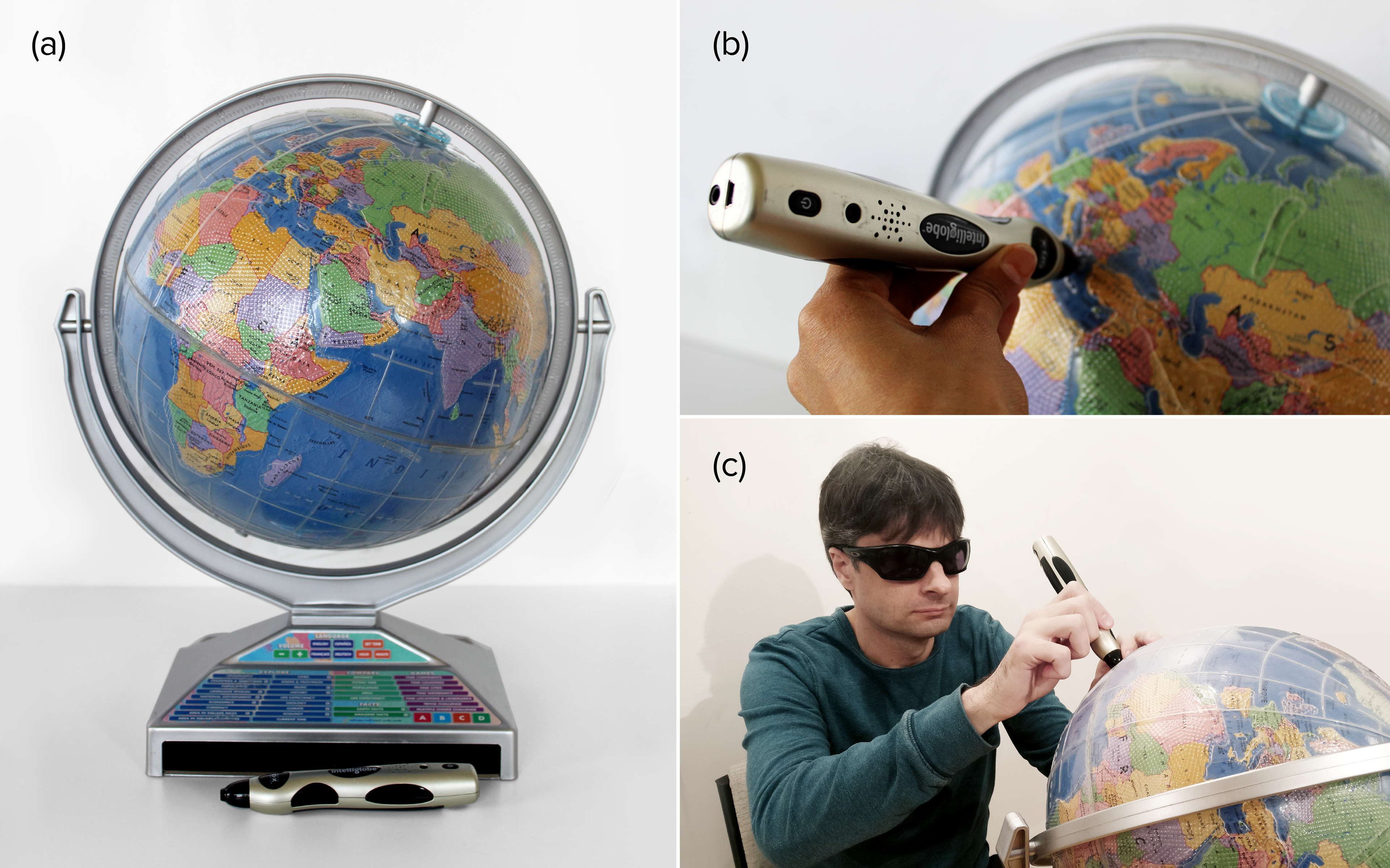
a: A customized interactive audio-tactile earth globe made by P1, Intelliglobe with APH tactile overlay.
b: Close-up view of APH overlay with Intellipen.
c: P1 using self-made interactive audio-tactile globe.
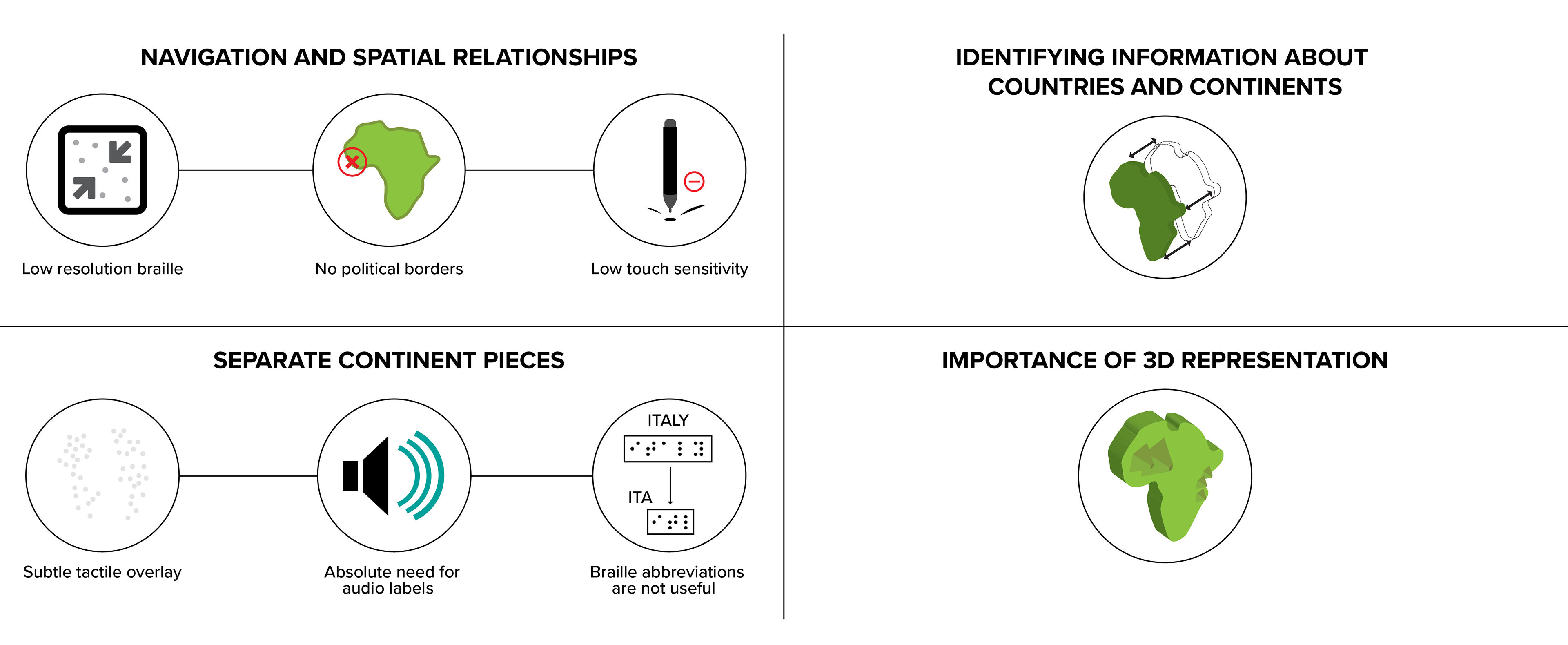
Insights gathered from P1’s globe:
1. Simultaneously overcoming limitations of both the Intelliglobe and the APH tactile overlay by combining them:
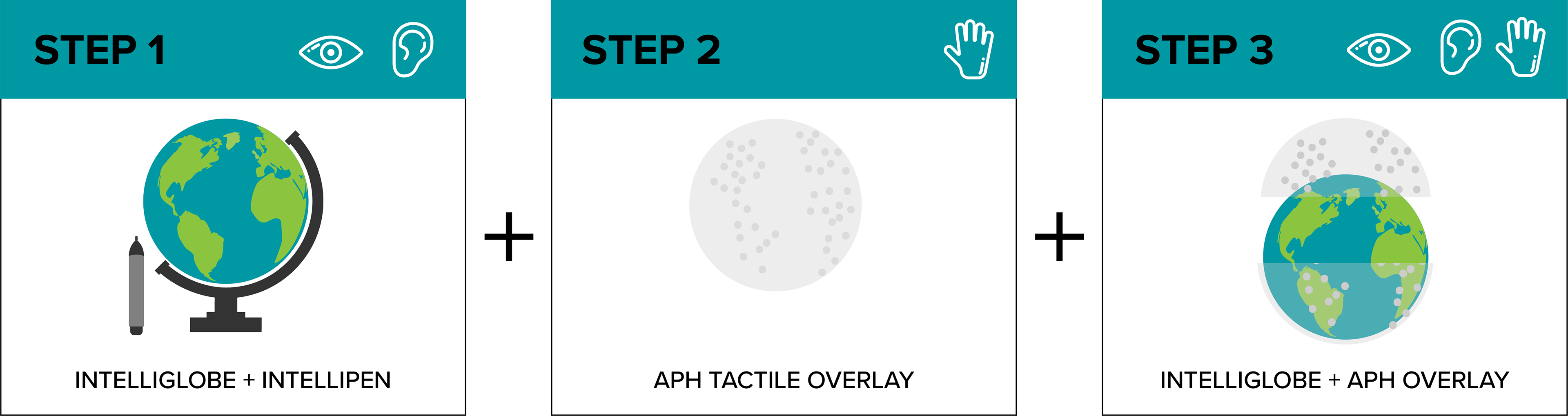
The lack of tactile features on the Intelliglobe was a leading motivation for P1’s DIY solution to combine the APH tactile overlay with the Intelliglobe. For P1, the Intelliglobe included an advantage and a critical problem: It was advantageous in that, unlike the tactile APH overlay, it conveyed abstract categories (country names, for example) in the form of audio labels. However, the fact that it was completely smooth was a problem because he had no access to information about the types of concrete structures (such as the shapes of continents) that would ordinarily be represented by the outlines and shading of a visually-oriented globe for sighted audiences. Attaching the tactile APH overlay to the Intelliglobe was a big improvement because it enabled P1 to access information about concrete structures of the Earth (such as the shapes of continents). Simultaneously, this solution counteracted shortcoming of the tactile APH overlay, that included only iconic representations but no symbolic representations.
2. Limitations of P1’s DIY solution:
a. Navigation and spatial relationships: Navigating various land masses was time-consuming due to the low spatial resolution of the braille overlay and a lack of political borders. In conversations with P1, I learned that since the Intelliglobe and Intellipen were not designed to be used with the tactile overlay, the pen could have some deficiencies with registering the locational information through the overlay. This required P1 to to press down multiple times at the same location to trigger the sonic label, causing confusion about where the pen is on the globe.
b. Identifying information about countries and continents: While the APH tactile overlay provides some shape and size information via raised lines and textures, the elevations of these raised lines and textures was not enough for P1 to identify and distinguish countries and continents. Additionally, P1 also mentioned that it was almost impossible to recognize the countries without audio labels. Braille abbreviations are typically used as country labels in raised line graphics maps, which increases the effort required to identify labelled items such as countries (for example, in a raised lined graphics map, ITALY might be represented by “ITA” in braille).
c. Separate continent pieces: Studying P1’s globe allowed me to find a previous discovery that was not reported in academic literature:Over a century ago, the Perkins School for the Blind also supported the need to have tangible 3D removable pieces to teach blind students shapes of continents and countries. Having removable continent pieces would reduce the rthe cacophony of many crisscrossing lines. Also, it would be much easier to understand the boundaries of the continents since haptic exploration affords a quicker and more complete perception of continent shapes.
d. Importance of 3D representation: P1 also spoke about some of the shortcomings of raised-line graphics in terms of how much detail can be communicated with changes in texture. The subtle textures of the overlay used to represent the changes in topography lacked detail. Similar to what I found in the literature, one observation I made during this session was that raised-lines surface maps may not be as effective as a full 3D model. This was because it was essential to use genuine GIS scaled topography to depict land elevations.